
By Professor Helen Fulton, Chair in Medieval Literature, Department of English
One of my research directions is aimed towards medieval towns and urban culture, especially in the region of the March of Wales. Some while ago I collaborated on an Arts and Humanities Research Council (AHRC) project on medieval Chester which resulted in an online map of the medieval streetscape of the city, with links to its major churches and buildings. This inspired an interest in the possibilities of mapping – both digital and hard copy – as a tool for research, education, and public engagement.
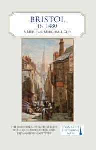
As a Trustee of the Historic Towns Trust (HTT), which produces hard-copy maps of historic towns throughout the UK, I took on the leadership of a project to produce a map of medieval Bristol, which was published in December 2020. I worked in partnership with Professor Peter Fleming at UWE, a renowned expert on medieval Bristol, and a team of local historians and archaeologists from the city of Bristol. Our first job was to decide roughly what period of time would be covered by the map – it is possible to layer maps on top of each other to show features and streetscapes from different periods of time, and some of the HTT maps have done exactly that. For Bristol, however, it made sense to focus quite precisely on the year 1480, when a well-networked Bristolian, William Worcestre, made a survey of the city of Bristol on foot, literally counting how many paces there were between landmarks. Using this survey, together with many other historical records of the city, the team was able to reconstruct the layout of Bristol in 1480, along with its major churches, abbeys, gentry houses, taverns, industrial buildings, and even its water supply.
The production of this unique map was funded partly by public donations and partly by a generous grant from the University of Bristol Knowledge Exchange fund. We used the money to employ a research assistant, Dr Bethany Whalley, who researched the history of the various streets and buildings that are described in the Gazetteer on the back of the map. Crucial information was also supplied by our team of local experts, each of whom had specialised knowledge of the city’s history. I co-wrote the introduction to the map, describing the work of William Worcestre, and edited all the textual information on the map, including the street names and other words on the map itself as well as the Gazetteer. We worked closely with the HTT cartographer, Giles Darkes, whose beautiful artwork makes all the HTT maps stand out not only as useful reference guides but as works of art.
Despite being published during a pandemic lockdown, the map has sold very well and has been the topic of numerous public lectures, in person and online. The map was launched during the Fifteenth Century Conference in early September at St James Priory. We are now planning a workshop at the annual Historical Association conference to be held in Bristol in May 2022, and we are working with an educational consultant to produce a study package for Key Stage 2 students.